|
| at: |
Sabine National Forest |
Data from USFS GIS
 show on map
 animate
Trail users:


Elevation Profile
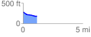
 1.155493 mi
 2.91 ft
 102.48 ft
 -99.57 ft
 1.68 %
GPX Downloads: Track Route
![]()
|
| at: |
Sabine National Forest |
show on map
animate
1.155493 mi
2.91 ft
102.48 ft
-99.57 ft
1.68 %