|
| at: |
Sabine National Forest |
Data from USFS GIS
 show on map
 animate
Trail users:


Elevation Profile
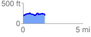
 1.942092 mi
 284.71 ft
 246.06 ft
 38.64 ft
 2.78 %
GPX Downloads: Track Route
![]()
|
| at: |
Sabine National Forest |
show on map
animate
1.942092 mi
284.71 ft
246.06 ft
38.64 ft
2.78 %