|
| at: |
Sabine National Forest |
Data from USFS GIS
 show on map
 animate
Trail users:


Elevation Profile
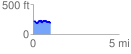
 1.012763 mi
 103.69 ft
 125.73 ft
 -22.05 ft
 2.35 %
GPX Downloads: Track Route
![]()
|
| at: |
Sabine National Forest |
show on map
animate
1.012763 mi
103.69 ft
125.73 ft
-22.05 ft
2.35 %