|
| at: |
Sabine National Forest |
Data from USFS GIS
 show on map
 animate
Trail users:


Elevation Profile
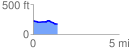
 1.423753 mi
 29.60 ft
 86.90 ft
 -57.30 ft
 1.16 %
GPX Downloads: Track Route
![]()
|
| at: |
Sabine National Forest |
show on map
animate
1.423753 mi
29.60 ft
86.90 ft
-57.30 ft
1.16 %