|
| at: |
Sabine National Forest |
Data from USFS GIS
 show on map
 animate
Trail users:


Elevation Profile
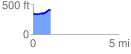
 1.014010 mi
 109.66 ft
 51.86 ft
 57.80 ft
 2.05 %
GPX Downloads: Track Route
![]()
|
| at: |
Sabine National Forest |
show on map
animate
1.014010 mi
109.66 ft
51.86 ft
57.80 ft
2.05 %