| at: |
Sabine National Forest |
Data from USFS GIS
 show on map
 animate
Trail users:


Elevation Profile
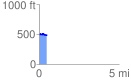
 0.482316 mi
 23.58 ft
 38.42 ft
 -14.84 ft
 1.51 %
GPX Downloads: Track Route
![]()
| at: |
Sabine National Forest |
show on map
animate
0.482316 mi
23.58 ft
38.42 ft
-14.84 ft
1.51 %