| at: |
Sabine National Forest |
Data from USFS GIS
 show on map
 animate
Trail users:


Elevation Profile
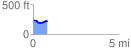
 0.844068 mi
 34.26 ft
 55.17 ft
 -20.91 ft
 1.24 %
GPX Downloads: Track Route
![]()
| at: |
Sabine National Forest |
show on map
animate
0.844068 mi
34.26 ft
55.17 ft
-20.91 ft
1.24 %