|
| at: |
Sabine National Forest |
Data from USFS GIS
 show on map
 animate
Trail users:


Elevation Profile
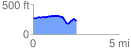
 2.526805 mi
 193.04 ft
 230.68 ft
 -37.64 ft
 1.73 %
GPX Downloads: Track Route
![]()
|
| at: |
Sabine National Forest |
show on map
animate
2.526805 mi
193.04 ft
230.68 ft
-37.64 ft
1.73 %