|
| at: |
Sabine National Forest |
Data from USFS GIS
 show on map
 animate
Trail users:


Elevation Profile
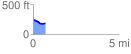
 0.708694 mi
 13.24 ft
 68.59 ft
 -55.35 ft
 1.83 %
GPX Downloads: Track Route
![]()
|
| at: |
Sabine National Forest |
show on map
animate
0.708694 mi
13.24 ft
68.59 ft
-55.35 ft
1.83 %