| at: |
Sabine National Forest |
Data from USFS GIS
 show on map
 animate
Trail users:


Elevation Profile
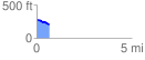
 0.668703 mi
 8.67 ft
 81.63 ft
 -72.96 ft
 2.31 %
GPX Downloads: Track Route
![]()
| at: |
Sabine National Forest |
show on map
animate
0.668703 mi
8.67 ft
81.63 ft
-72.96 ft
2.31 %