| at: |
Sabine National Forest |
Data from USFS GIS
 show on map
 animate
Trail users:


Elevation Profile
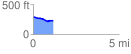
 1.179139 mi
 16.84 ft
 74.52 ft
 -57.68 ft
 1.20 %
GPX Downloads: Track Route
![]()
| at: |
Sabine National Forest |
show on map
animate
1.179139 mi
16.84 ft
74.52 ft
-57.68 ft
1.20 %