| at: |
Sabine National Forest |
Data from USFS GIS
 show on map
 animate
Trail users:


Elevation Profile
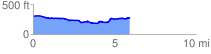
 6.011078 mi
 244.65 ft
 276.76 ft
 -32.11 ft
 0.87 %
GPX Downloads: Track Route
![]()
| at: |
Sabine National Forest |
show on map
animate
6.011078 mi
244.65 ft
276.76 ft
-32.11 ft
0.87 %