| at: |
Sabine National Forest |
Data from USFS GIS
 show on map
 animate
Trail users:


Elevation Profile
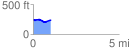
 1.048889 mi
 55.32 ft
 64.21 ft
 -8.88 ft
 1.16 %
GPX Downloads: Track Route
![]()
| at: |
Sabine National Forest |
show on map
animate
1.048889 mi
55.32 ft
64.21 ft
-8.88 ft
1.16 %