| at: |
Sabine National Forest |
Data from USFS GIS
 show on map
 animate
Trail users:


Elevation Profile
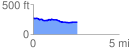
 2.586679 mi
 69.53 ft
 143.91 ft
 -74.38 ft
 1.05 %
GPX Downloads: Track Route
![]()
| at: |
Sabine National Forest |
show on map
animate
2.586679 mi
69.53 ft
143.91 ft
-74.38 ft
1.05 %