| at: |
Sabine National Forest |
Data from USFS GIS
 show on map
 animate
Trail users:


Elevation Profile
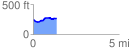
 1.360318 mi
 101.43 ft
 82.40 ft
 19.03 ft
 1.41 %
GPX Downloads: Track Route
![]()
| at: |
Sabine National Forest |
show on map
animate
1.360318 mi
101.43 ft
82.40 ft
19.03 ft
1.41 %