| at: |
Sabine National Forest |
Data from USFS GIS
 show on map
 animate
Trail users:


Elevation Profile
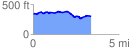
 3.398144 mi
 219.17 ft
 267.44 ft
 -48.27 ft
 1.49 %
GPX Downloads: Track Route
![]()
| at: |
Sabine National Forest |
show on map
animate
3.398144 mi
219.17 ft
267.44 ft
-48.27 ft
1.49 %