| at: |
Sabine National Forest |
Data from USFS GIS
 show on map
 animate
Trail users:


Elevation Profile
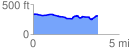
 3.774941 mi
 170.39 ft
 198.78 ft
 -28.39 ft
 1.00 %
GPX Downloads: Track Route
![]()
| at: |
Sabine National Forest |
show on map
animate
3.774941 mi
170.39 ft
198.78 ft
-28.39 ft
1.00 %