|
| at: |
Sabine National Forest |
Data from USFS GIS
 show on map
 animate
Trail users:


Elevation Profile
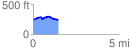
 1.452847 mi
 97.13 ft
 93.39 ft
 3.74 ft
 1.27 %
GPX Downloads: Track Route
![]()
|
| at: |
Sabine National Forest |
show on map
animate
1.452847 mi
97.13 ft
93.39 ft
3.74 ft
1.27 %