|
| at: |
Sabine National Forest |
Data from USFS GIS
 show on map
 animate
Trail users:


Elevation Profile
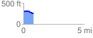
 0.819927 mi
 23.55 ft
 75.96 ft
 -52.42 ft
 1.75 %
GPX Downloads: Track Route
![]()
|
| at: |
Sabine National Forest |
show on map
animate
0.819927 mi
23.55 ft
75.96 ft
-52.42 ft
1.75 %