|
| at: |
Sabine National Forest |
Data from USFS GIS
 show on map
 animate
Trail users:


Elevation Profile
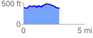
 3.070064 mi
 238.59 ft
 216.37 ft
 22.22 ft
 1.47 %
GPX Downloads: Track Route
![]()
|
| at: |
Sabine National Forest |
show on map
animate
3.070064 mi
238.59 ft
216.37 ft
22.22 ft
1.47 %