| at: |
Sabine National Forest |
Data from USFS GIS
 show on map
 animate
Trail users:


Elevation Profile
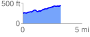
 3.256149 mi
 312.66 ft
 137.65 ft
 175.01 ft
 1.82 %
GPX Downloads: Track Route
![]()
| at: |
Sabine National Forest |
show on map
animate
3.256149 mi
312.66 ft
137.65 ft
175.01 ft
1.82 %