| at: |
Sabine National Forest |
Data from USFS GIS
 show on map
 animate
Trail users:


Elevation Profile
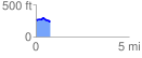
 0.778367 mi
 46.20 ft
 80.55 ft
 -34.36 ft
 1.96 %
GPX Downloads: Track Route
![]()
| at: |
Sabine National Forest |
show on map
animate
0.778367 mi
46.20 ft
80.55 ft
-34.36 ft
1.96 %