|
| at: |
Sabine National Forest |
Data from USFS GIS
 show on map
 animate
Trail users:


Elevation Profile
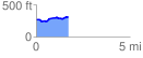
 1.709129 mi
 115.37 ft
 81.50 ft
 33.87 ft
 1.28 %
GPX Downloads: Track Route
![]()
|
| at: |
Sabine National Forest |
show on map
animate
1.709129 mi
115.37 ft
81.50 ft
33.87 ft
1.28 %