| at: |
Sabine National Forest |
Data from USFS GIS
 show on map
 animate
Trail users:


Elevation Profile
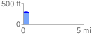
 0.474339 mi
 7.75 ft
 31.91 ft
 -24.16 ft
 1.27 %
GPX Downloads: Track Route
![]()
| at: |
Sabine National Forest |
show on map
animate
0.474339 mi
7.75 ft
31.91 ft
-24.16 ft
1.27 %