|
| at: |
Sabine National Forest |
Data from USFS GIS
 show on map
 animate
Trail users:


Elevation Profile
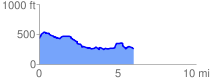
 6.095814 mi
 482.68 ft
 653.01 ft
 -170.33 ft
 2.03 %
GPX Downloads: Track Route
![]()
|
| at: |
Sabine National Forest |
show on map
animate
6.095814 mi
482.68 ft
653.01 ft
-170.33 ft
2.03 %