| at: |
Sabine National Forest |
Data from USFS GIS
 show on map
 animate
Trail users:


Elevation Profile
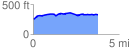
 3.789474 mi
 204.68 ft
 130.71 ft
 73.97 ft
 1.02 %
GPX Downloads: Track Route
![]()
| at: |
Sabine National Forest |
show on map
animate
3.789474 mi
204.68 ft
130.71 ft
73.97 ft
1.02 %