| at: |
Sabine National Forest |
Data from USFS GIS
 show on map
 animate
Trail users:


Elevation Profile
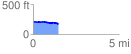
 1.487895 mi
 24.11 ft
 57.94 ft
 -33.82 ft
 0.74 %
GPX Downloads: Track Route
![]()
| at: |
Sabine National Forest |
show on map
animate
1.487895 mi
24.11 ft
57.94 ft
-33.82 ft
0.74 %