| at: |
Sabine National Forest |
Data from USFS GIS
 show on map
 animate
Trail users:


Elevation Profile
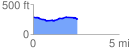
 2.587357 mi
 84.92 ft
 125.98 ft
 -41.06 ft
 0.92 %
GPX Downloads: Track Route
![]()
| at: |
Sabine National Forest |
show on map
animate
2.587357 mi
84.92 ft
125.98 ft
-41.06 ft
0.92 %