| at: |
Sabine National Forest |
Data from USFS GIS
 show on map
 animate
Trail users:


Elevation Profile
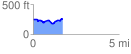
 1.709758 mi
 161.28 ft
 135.69 ft
 25.59 ft
 1.79 %
GPX Downloads: Track Route
![]()
| at: |
Sabine National Forest |
show on map
animate
1.709758 mi
161.28 ft
135.69 ft
25.59 ft
1.79 %