| at: |
Sabine National Forest |
Data from USFS GIS
 show on map
 animate
Trail users:


Elevation Profile
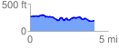
 4.155675 mi
 286.73 ft
 362.32 ft
 -75.58 ft
 1.65 %
GPX Downloads: Track Route
![]()
| at: |
Sabine National Forest |
show on map
animate
4.155675 mi
286.73 ft
362.32 ft
-75.58 ft
1.65 %