| at: |
Sabine National Forest |
Data from USFS GIS
 show on map
 animate
Trail users:


Elevation Profile
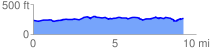
 9.326253 mi
 418.69 ft
 376.37 ft
 42.32 ft
 0.85 %
GPX Downloads: Track Route
![]()
| at: |
Sabine National Forest |
show on map
animate
9.326253 mi
418.69 ft
376.37 ft
42.32 ft
0.85 %