| at: |
Sabine National Forest |
Data from USFS GIS
 show on map
 animate
Trail users:


Elevation Profile
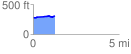
 1.276820 mi
 56.35 ft
 29.89 ft
 26.46 ft
 0.84 %
GPX Downloads: Track Route
![]()
| at: |
Sabine National Forest |
show on map
animate
1.276820 mi
56.35 ft
29.89 ft
26.46 ft
0.84 %