| at: |
Sabine National Forest |
Data from USFS GIS
 show on map
 animate
Trail users:


Elevation Profile
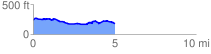
 5.044255 mi
 216.84 ft
 293.26 ft
 -76.43 ft
 1.10 %
GPX Downloads: Track Route
![]()
| at: |
Sabine National Forest |
show on map
animate
5.044255 mi
216.84 ft
293.26 ft
-76.43 ft
1.10 %