| at: |
Sabine National Forest |
Data from USFS GIS
 show on map
 animate
Trail users:


Elevation Profile
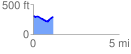
 1.162404 mi
 82.22 ft
 108.49 ft
 -26.27 ft
 1.77 %
GPX Downloads: Track Route
![]()
| at: |
Sabine National Forest |
show on map
animate
1.162404 mi
82.22 ft
108.49 ft
-26.27 ft
1.77 %