| at: |
Sabine National Forest |
Data from USFS GIS
 show on map
 animate
Trail users:


Elevation Profile
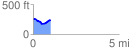
 1.010745 mi
 82.64 ft
 98.27 ft
 -15.63 ft
 1.84 %
GPX Downloads: Track Route
![]()
| at: |
Sabine National Forest |
show on map
animate
1.010745 mi
82.64 ft
98.27 ft
-15.63 ft
1.84 %