| at: |
Sabine National Forest |
Data from USFS GIS
 show on map
 animate
Trail users:


Elevation Profile
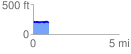
 0.902745 mi
 50.02 ft
 44.66 ft
 5.36 ft
 1.05 %
GPX Downloads: Track Route
![]()
| at: |
Sabine National Forest |
show on map
animate
0.902745 mi
50.02 ft
44.66 ft
5.36 ft
1.05 %