| at: |
Sabine National Forest |
Data from USFS GIS
 show on map
 animate
Trail users:


Elevation Profile
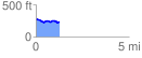
 1.250840 mi
 59.68 ft
 101.62 ft
 -41.93 ft
 1.54 %
GPX Downloads: Track Route
![]()
| at: |
Sabine National Forest |
show on map
animate
1.250840 mi
59.68 ft
101.62 ft
-41.93 ft
1.54 %