| at: |
Sabine National Forest |
Data from USFS GIS
 show on map
 animate
Trail users:


Elevation Profile
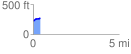
 0.448185 mi
 52.63 ft
 1.56 ft
 51.07 ft
 2.22 %
GPX Downloads: Track Route
![]()
| at: |
Sabine National Forest |
show on map
animate
0.448185 mi
52.63 ft
1.56 ft
51.07 ft
2.22 %