| at: |
Sabine National Forest |
Data from USFS GIS
 show on map
 animate
Trail users:


Elevation Profile
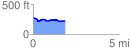
 1.880847 mi
 71.09 ft
 132.85 ft
 -61.76 ft
 1.34 %
GPX Downloads: Track Route
![]()
| at: |
Sabine National Forest |
show on map
animate
1.880847 mi
71.09 ft
132.85 ft
-61.76 ft
1.34 %