| at: |
Sabine National Forest |
Data from USFS GIS
 show on map
 animate
Trail users:


Elevation Profile
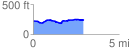
 2.974425 mi
 157.62 ft
 124.81 ft
 32.82 ft
 1.00 %
GPX Downloads: Track Route
![]()
| at: |
Sabine National Forest |
show on map
animate
2.974425 mi
157.62 ft
124.81 ft
32.82 ft
1.00 %