| at: |
Sabine National Forest |
Data from USFS GIS
 show on map
 animate
Trail users:


Elevation Profile
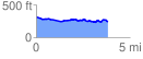
 3.854576 mi
 198.16 ft
 281.49 ft
 -83.33 ft
 1.38 %
GPX Downloads: Track Route
![]()
| at: |
Sabine National Forest |
show on map
animate
3.854576 mi
198.16 ft
281.49 ft
-83.33 ft
1.38 %