| at: |
Sabine National Forest |
Data from USFS GIS
 show on map
 animate
Trail users:


Elevation Profile
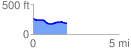
 1.985219 mi
 39.81 ft
 125.35 ft
 -85.54 ft
 1.20 %
GPX Downloads: Track Route
![]()
| at: |
Sabine National Forest |
show on map
animate
1.985219 mi
39.81 ft
125.35 ft
-85.54 ft
1.20 %