| at: |
Sabine National Forest |
Data from USFS GIS
 show on map
 animate
Trail users:


Elevation Profile
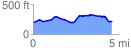
 4.616090 mi
 340.12 ft
 310.89 ft
 29.23 ft
 1.40 %
GPX Downloads: Track Route
![]()
| at: |
Sabine National Forest |
show on map
animate
4.616090 mi
340.12 ft
310.89 ft
29.23 ft
1.40 %