| at: |
Sabine National Forest |
Data from USFS GIS
 show on map
 animate
Trail users:


Elevation Profile
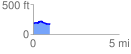
 0.989021 mi
 43.53 ft
 51.03 ft
 -7.50 ft
 0.98 %
GPX Downloads: Track Route
![]()
| at: |
Sabine National Forest |
show on map
animate
0.989021 mi
43.53 ft
51.03 ft
-7.50 ft
0.98 %