| at: |
Sabine National Forest |
Data from USFS GIS
 show on map
 animate
Trail users:


Elevation Profile
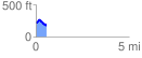
 0.558942 mi
 62.97 ft
 126.46 ft
 -63.48 ft
 4.28 %
GPX Downloads: Track Route
![]()
| at: |
Sabine National Forest |
show on map
animate
0.558942 mi
62.97 ft
126.46 ft
-63.48 ft
4.28 %