| at: |
Sabine National Forest |
Data from USFS GIS
 show on map
 animate
Trail users:


Elevation Profile
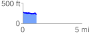
 1.162521 mi
 55.12 ft
 100.13 ft
 -45.01 ft
 1.63 %
GPX Downloads: Track Route
![]()
| at: |
Sabine National Forest |
show on map
animate
1.162521 mi
55.12 ft
100.13 ft
-45.01 ft
1.63 %