| at: |
Sabine National Forest |
Data from USFS GIS
 show on map
 animate
Trail users:


Elevation Profile
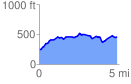
 4.891429 mi
 560.14 ft
 345.62 ft
 214.52 ft
 2.17 %
GPX Downloads: Track Route
![]()
| at: |
Sabine National Forest |
show on map
animate
4.891429 mi
560.14 ft
345.62 ft
214.52 ft
2.17 %