| at: |
Sabine National Forest |
Data from USFS GIS
 show on map
 animate
Trail users:


Elevation Profile
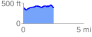
 2.576104 mi
 224.06 ft
 214.56 ft
 9.50 ft
 1.65 %
GPX Downloads: Track Route
![]()
| at: |
Sabine National Forest |
show on map
animate
2.576104 mi
224.06 ft
214.56 ft
9.50 ft
1.65 %