| at: |
Sabine National Forest |
Data from USFS GIS
 show on map
 animate
Trail users:


Elevation Profile
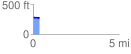
 0.370773 mi
 0.97 ft
 17.87 ft
 -16.90 ft
 0.91 %
GPX Downloads: Track Route
![]()
| at: |
Sabine National Forest |
show on map
animate
0.370773 mi
0.97 ft
17.87 ft
-16.90 ft
0.91 %