| at: |
Sabine National Forest |
Data from USFS GIS
 show on map
 animate
Trail users:


Elevation Profile
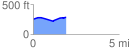
 1.909170 mi
 96.47 ft
 70.88 ft
 25.59 ft
 0.96 %
GPX Downloads: Track Route
![]()
| at: |
Sabine National Forest |
show on map
animate
1.909170 mi
96.47 ft
70.88 ft
25.59 ft
0.96 %